Word to the Wise: Southwest Peace River area overview
October 25, 2022
Each week, XI Technologies scans its unique combination of enhanced industry data to provide trends and insights that have value for professionals doing business in the WCSB. If you’d like the Word to the Wise delivered directly to your inbox, subscribe here.
The prolific Peace River region has long been an area of oil and gas activity, dating as far back as 1921, with the first significant producing well spudded in 1948 and still producing to this day. This week we’ll take a deep dive into this area covering a large area on the southwest side of the Peace River Region.
The total current production is broken up into 82% gas (predominately from the Montney/Doig formation) and 18% oil. Many of the newer oil wells are produced from Montney and Charlie Lake formations, with Charlie Lake seeming to be the new focus of the area.
Looking at the wells being produced in the last year, and excluding production from the Montney formation, the percentages have shifted, with oil increasing to 42% of the production and gas decreasing to 58%.
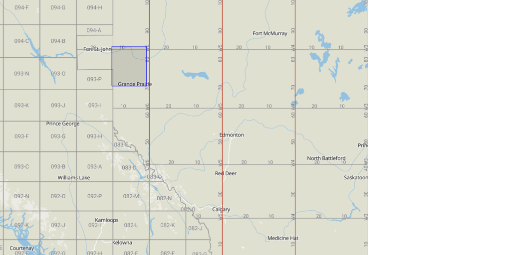
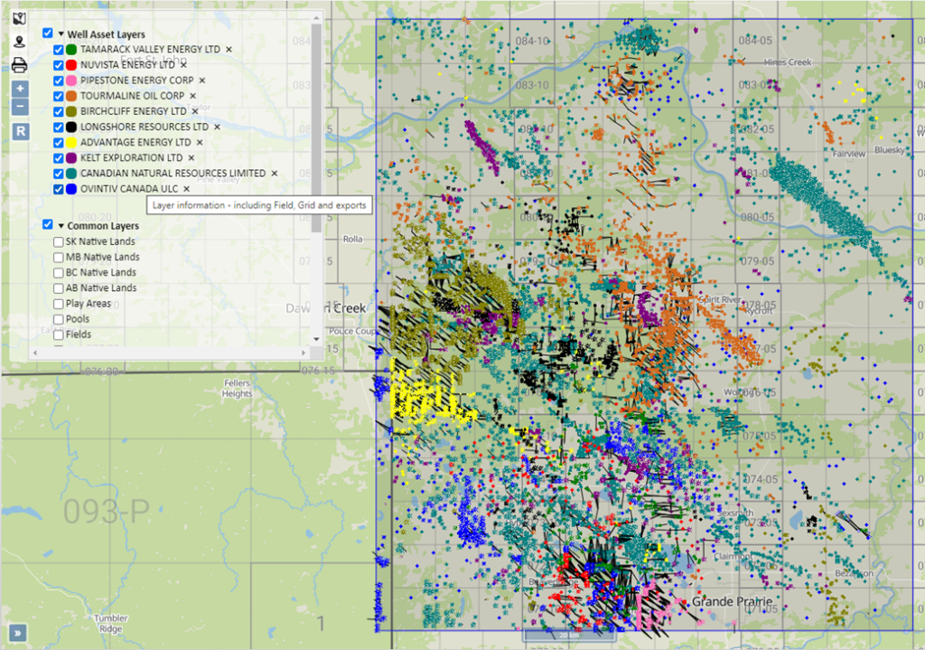
Note: for the purposes of this article, we define the Southwest Peace River area by the outlines in the below screenshot.
Ownership in Southwest Peace River Area Assets
The top 10 companies own 86% of the assets in this area but there are a total of 58 companies with currently producing assets. Out of that, there are 25 companies that have been active within the last year.
Click here to download a report of all companies in the Southwest Peace River area.
Southwest Peace River area zones
Digging deeper into the data, you can see that Montney, Charlie Lake, and a zone comprised of new wells the government has not assigned yet make up more than 96% of the area’s current production. It is evident this new production is a mix of Charlie Lake and Montney, keeping in the trend of drilling in this area.
This graph shows the production breakdown by zone:
Production history of Southwest Peace River assets
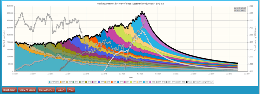
Let’s investigate the Peace River area a little further. Looking at the vintage of this production, while there is a good chunk of production coming from pre-2007 wells, the gross well count was high until 2015 and you can see a rapid drop in early 2020. Then in mid-2020, it started ramping up again, as can be seen from the graph below.
Company operations
Looking at the top ten companies that are increasing production in the area, we can look at their inactive well and marginal well ratios to potentially give insight into operational efficiency.
This data is obtained from our LCA Report and a snapshot can be seen below:

Click here to download an LCA report on Southwest Peace River.
Expiring Land
Looking forward, are there any leases expiring in the next 2 years?
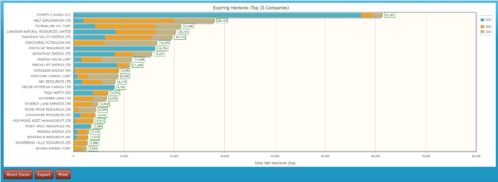
There are 512 crown leases expiring with a total of about 300,000 undeveloped hectares of land. Here’s a look at the expiring hectares by the top 25 companies in the next two years:
Liabilities in Southwest Peace River
Because this area is older and now unconventional, the ARO obligations become extremely important. If companies are hoping to acquire rich and long-lived Peace River assets, it is essential to look at liabilities among various acquisition opportunities to determine differences in future obligations.
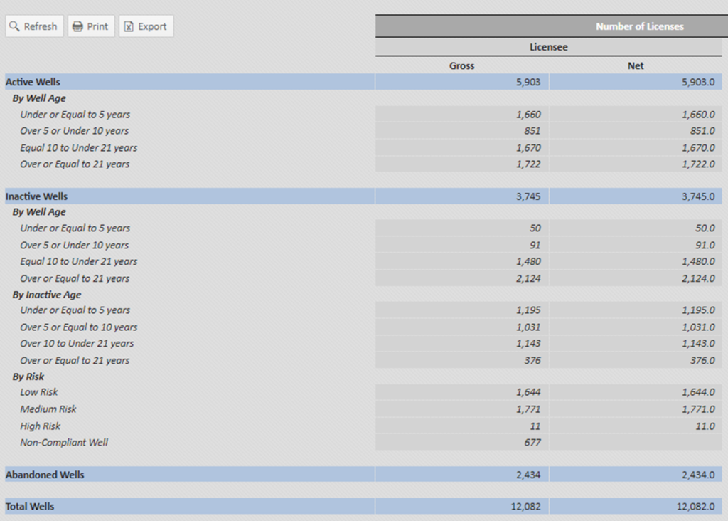
Being one of the oldest areas in Alberta, it’s no surprise there are a significant number of inactive wells in this area, particularly ones over 21 years in age. There is over $493 million of liability on inactive wells in this area or 5414 total inactive wells identified by the government.
Note: Liability costs displayed in the report below are based on XI’s ARO cost model.
Click here to download an ARO report on Southwest Peace River.
Emissions in Southwest Peace River
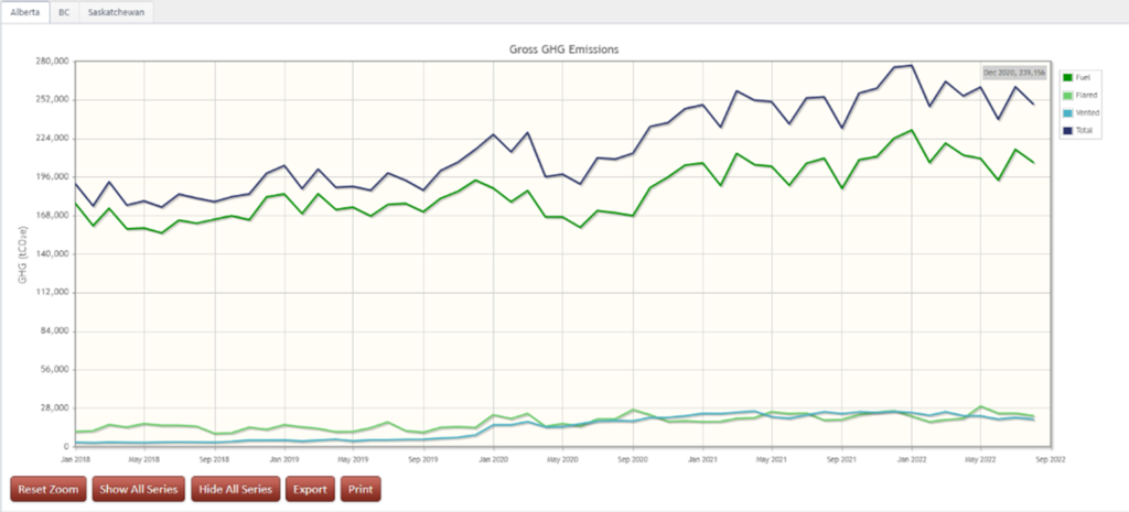
A quick snapshot of the Scope 1 GHG Emissions from the AssetBook Emissions Report for the total area shows that in the last 12 months, the field has produced approximately 3 million tonnes CO2e. 53% of the emissions come from the 10 largest gas plants or gathering systems in the area, operated by larger midstream or E&P companies.
This area has an established gas production infrastructure and an average gas conservation rate of 99%, where only 1% of gas produced ends up as emissions. The majority of emissions are from fuel use, with fuel emissions outweighing venting to flaring by 4 to 1.
Next week, we’ll look at this area from a drilling perspective to gain more insight.
____________________________________________________________________________________
If you’d like to learn more about how XI’s AssetSuite software can analyze companies, packages, or regions throughout Western Canada, visit our website or contact XI Technologies.
